2021-07-27 Flood in Myanmar on 27 July, 2021

Emergency Obs. Request Information

  • Disaster Type: Flood
  • Country: Myanmar
  • Occurrence Date (UTC): 27 July, 2021
  • SA activation Date(UTC): 28 July, 2021
  • Requester: ASEAN Coordinating Centre for Humanitarian Assistance on disaster management (AHA Centre)
  • Escalation to the International Charter: No
  • GLIDE Number: FL-2021-000095-MMR
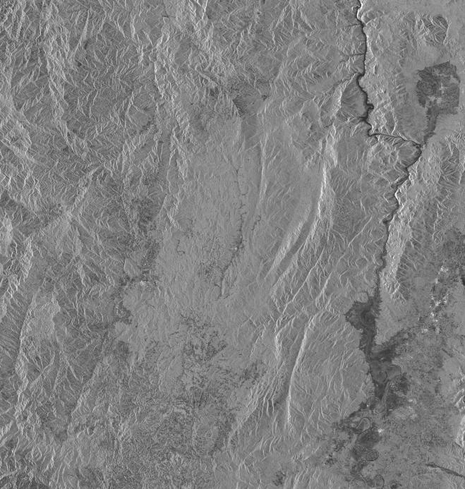
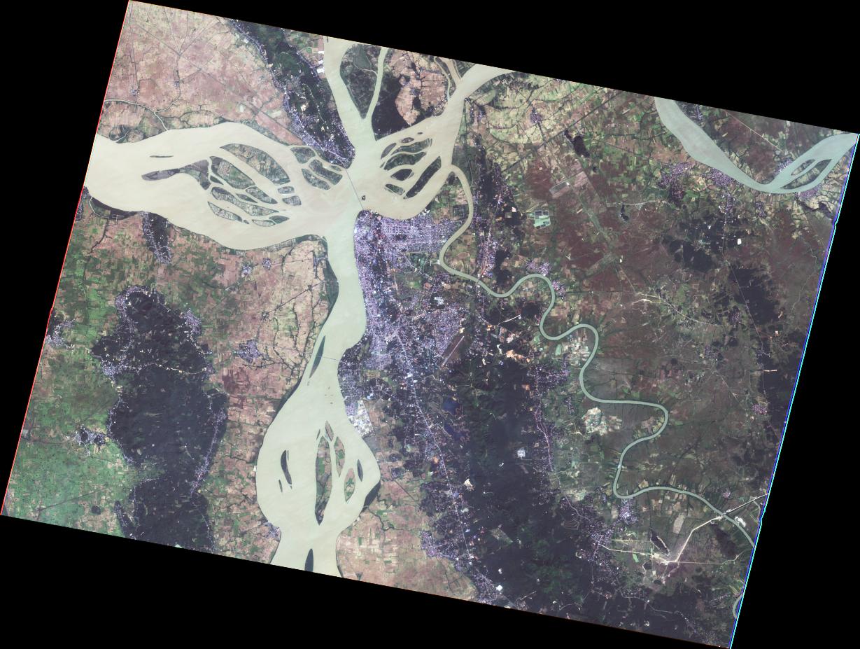
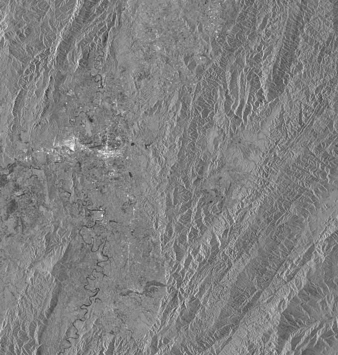
Disaster Situation

Heavy rains battered the southern states of Kayin and Mon and Tanintharyi region beginning on Sunday, impacting as many as 3,000 people. More than 100 in Kayin's Hlaingbwe had to be evacuated, according to a relief official from the area.

Product

   AIT   

2021-07-29

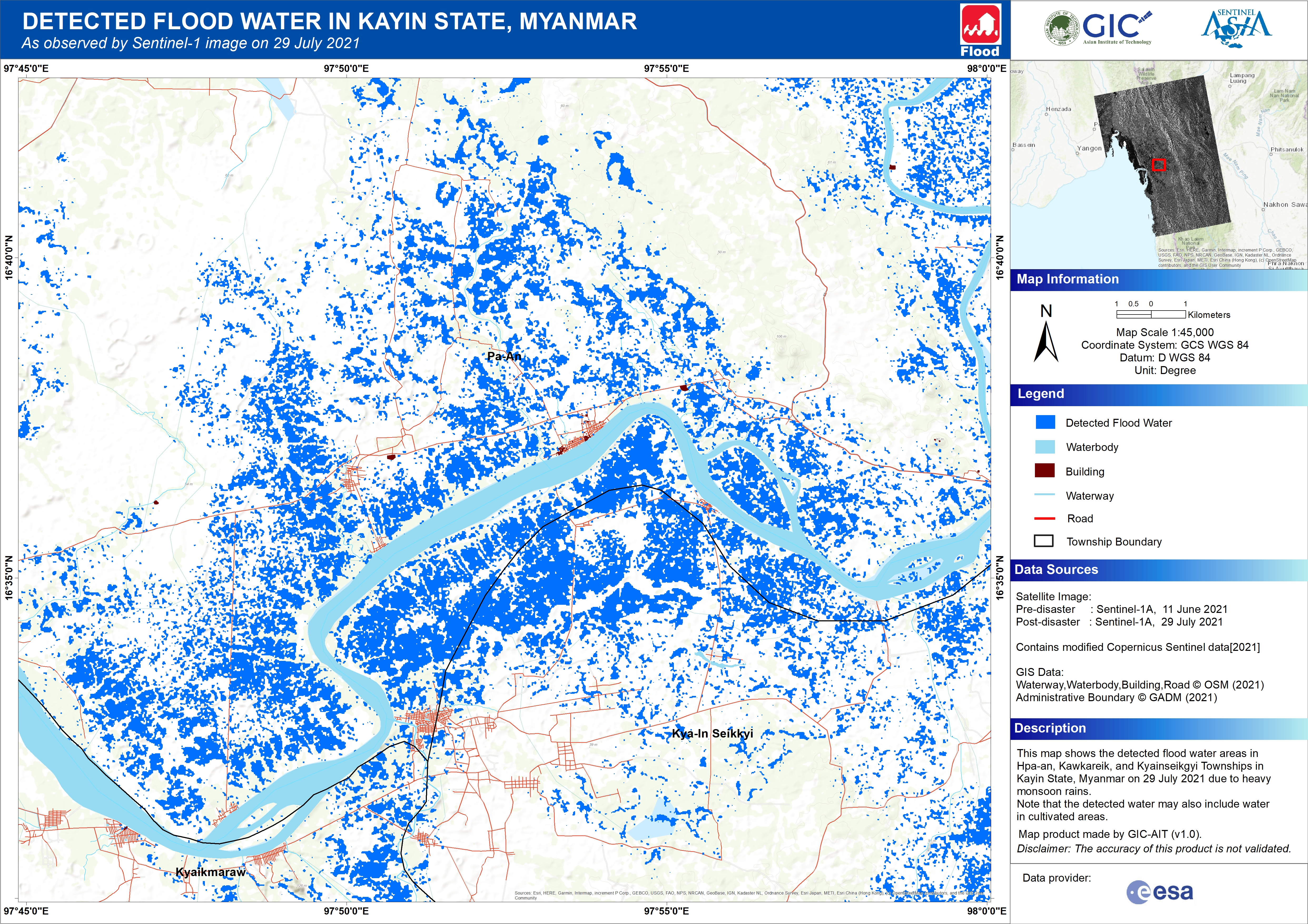
DETECTED FLOOD WATER IN KAYIN STATE, MYANMAR As observed by Sentinel-1 image on 29 July 2021
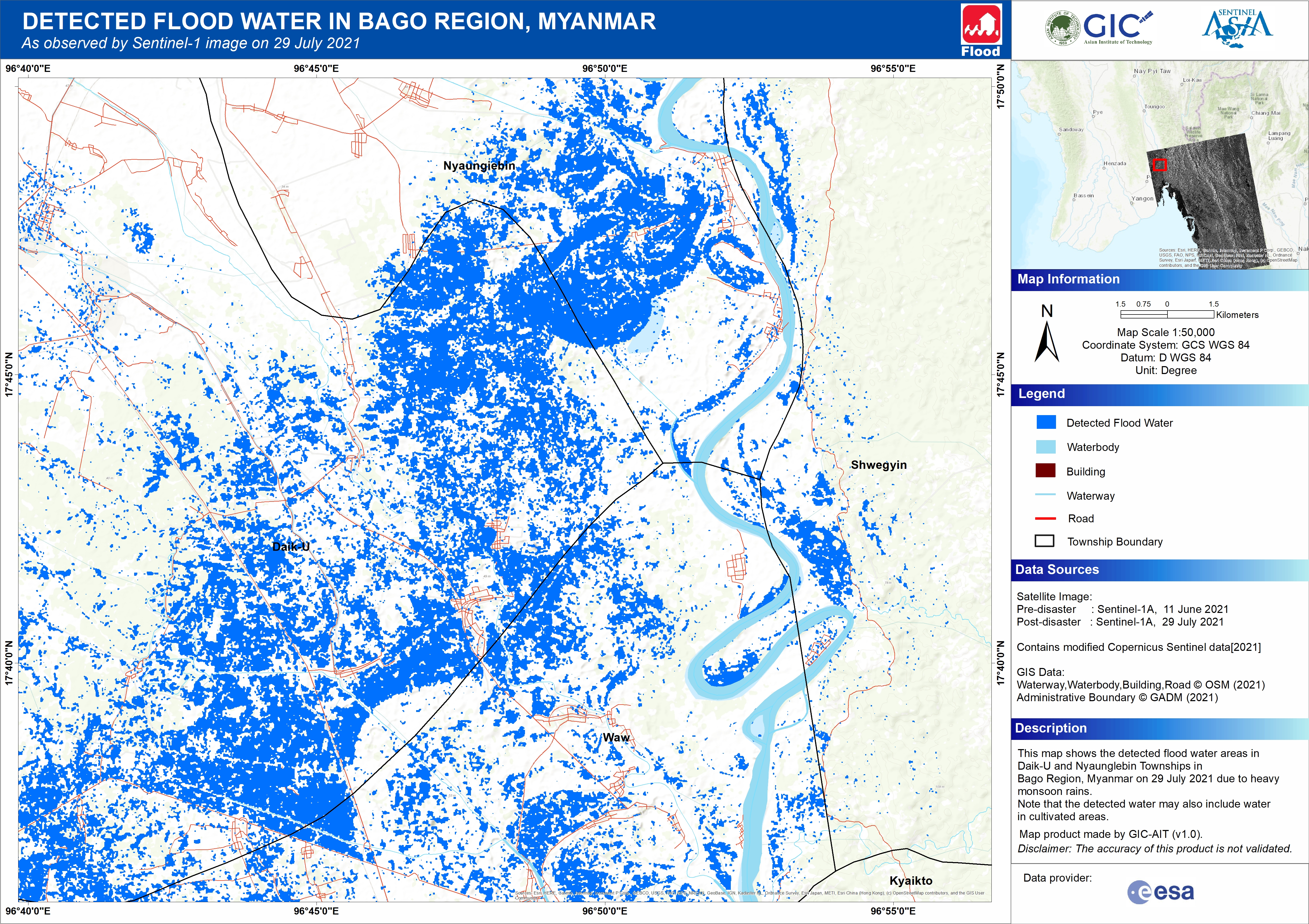

2021-07-29

DETECTED FLOOD WATER IN BAGO REGION, MYANMAR As observed by Sentinel-1 image on 29 July 2021


2021-07-29

DETECTED FLOOD WATER IN MYANMAR As observed by Sentinel-1 image on 29 July 2021


Web GIS

    Sentinel Asia member only.
    The account will be sent to the EOR requester after Web GIS page is prepared.
    If you are interested in to be a member of Sentinel Asia, please contact: z-sentinel.asia@ml.jaxa.jp


  • Flood in Myanmar on 27 July, 2021 see detail

Satellite Image

   Before Disaster   

   JAXA   

2021-03-11

ALOS-2 Level1.1
BRS HH ALOS2 36722/0300 2021/03/11 FBD R 1.1 __A

2021-03-11

ALOS-2 Level2.1
IMG HH ALOS2 36722/0300 2021/03/11 FBD R 2.1 GUA

2021-03-11

ALOS-2 Level1.1
BRS HH ALOS2 36722/0310 2021/03/11 FBD R 1.1 __A

2021-03-11

ALOS-2 Level2.1
IMG HH ALOS2 36722/0310 2021/03/11 FBD R 2.1 GUA

2021-03-11

ALOS-2 Level1.1
BRS HH ALOS2 36722/0320 2021/03/11 FBD R 1.1 __A

2021-03-11

ALOS-2 Level2.1
IMG HH ALOS2 36722/0320 2021/03/11 FBD R 2.1 GUA

2021-03-11

ALOS-2 Level1.1
BRS HH ALOS2 36722/0330 2021/03/11 FBD R 1.1 __A

2021-03-11

ALOS-2 Level2.1
IMG HH ALOS2 36722/0330 2021/03/11 FBD R 2.1 GUA

2021-03-11

ALOS-2 Level1.1
BRS HH ALOS2 36722/0340 2021/03/11 FBD R 1.1 __A

2021-03-11

ALOS-2 Level2.1
IMG HH ALOS2 36722/0340 2021/03/11 FBD R 2.1 GUA

2021-03-11

ALOS-2 Level1.1
BRS HH ALOS2 36722/0350 2021/03/11 FBD R 1.1 __A

2021-03-11

ALOS-2 Level2.1
IMG HH ALOS2 36722/0350 2021/03/11 FBD R 2.1 GUA

2021-03-11

ALOS-2 Level1.1
BRS HH ALOS2 36722/0360 2021/03/11 FBD R 1.1 __A

2021-03-11

ALOS-2 Level2.1
IMG HH ALOS2 36722/0360 2021/03/11 FBD R 2.1 GUA

   NARL   

2020-11-10

FORMOSAT-5 Level4 MS
FS5 G000 MS L4UTM 2020/11/10 04:44:31

2020-11-10

FORMOSAT-5 Level4 PAN
FS5 G000 PAN L4UTM 2020/11/10 04:44:31

2020-11-10

FORMOSAT-5 Level4 PMS
FS5 G000 PMS L4UTM 2020/11/10 04:44:31

   After Disaster   

   JAXA   

2021-07-29

ALOS-2 Level1.1
BRS HH ALOS2 38792/0300 2021/07/29 FBD R 1.1 __A

2021-07-29

ALOS-2 Level2.1
IMG HH ALOS2 38792/0300 2021/07/29 FBD R 2.1 GUA

2021-07-29

ALOS-2 Level1.1
BRS HH ALOS2 38792/0310 2021/07/29 FBD R 1.1 __A

2021-07-29

ALOS-2 Level2.1
IMG HH ALOS2 38792/0310 2021/07/29 FBD R 2.1 GUA

2021-07-29

ALOS-2 Level1.1
BRS HH ALOS2 38792/0320 2021/07/29 FBD R 1.1 __A

2021-07-29

ALOS-2 Level2.1
IMG HH ALOS2 38792/0320 2021/07/29 FBD R 2.1 GUA

2021-07-29

ALOS-2 Level1.1
BRS HH ALOS2 38792/0330 2021/07/29 FBD R 1.1 __A

2021-07-29

ALOS-2 Level2.1
IMG HH ALOS2 38792/0330 2021/07/29 FBD R 2.1 GUA

2021-07-29

ALOS-2 Level1.1
BRS HH ALOS2 38792/0340 2021/07/29 FBD R 1.1 __A

2021-07-29

ALOS-2 Level2.1
IMG HH ALOS2 38792/0340 2021/07/29 FBD R 2.1 GUA

2021-07-29

ALOS-2 Level1.1
BRS HH ALOS2 38792/0350 2021/07/29 FBD R 1.1 __A

2021-07-29

ALOS-2 Level2.1
IMG HH ALOS2 38792/0350 2021/07/29 FBD R 2.1 GUA

2021-07-29

ALOS-2 Level1.1
BRS HH ALOS2 38792/0360 2021/07/29 FBD R 1.1 __A

2021-07-29

ALOS-2 Level2.1
IMG HH ALOS2 38792/0360 2021/07/29 FBD R 2.1 GUA

   ISRO   

2021-07-30

Resourcesat-2 AW
Path=118 Row=064
30-JUL-2021 04:04:36

2021-07-30

Resourcesat-2 AW
Path=118 Row=059
30-JUL-2021 04:06:18