"Guide to Using Emergent Value-Added Products (EVAP) Module with QGIS for Disaster Response" by Taiwan Space Agency
In accordance with Sentinel Asia's strategic plan to empower local agencies with local data and Value-Added Products (VAPs) for addressing local needs, the Taiwan Space Agency (TASA) has developed a manual to facilitate the application of the EVAP module. This manual provides step-by-step instructions on how to utilize the EVAP module within QGIS to swiftly and easily identify disaster-affected areas.
Materials can be downloaded the links below:
1. Manual : "Introduction and Operation of the EVAP Module using QGIS" (PDF file): This manual provides detailed procedures along with video demonstrations for ease of understanding.
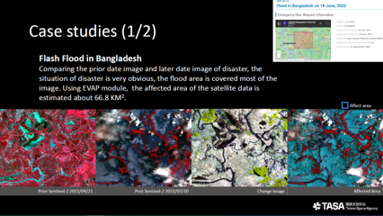
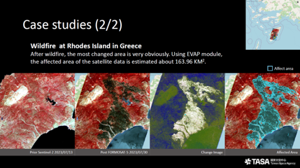
2. EVAP_case.zip : This folder contains two case studies – one depicting the flooding in Bangladesh and the other focusing on wildfires in Greece. Users can simply double-click the EVAP case.qgz file within each case folder to access and explore these cases.
Direction For Use:
| Folder name: Bangladesh |
| File name | Instruction manual |
|---|---|
| Clip_Bangladesh_20220421_1.jp2 | Prior date image from Sentinel-2 |
| Clip_Bangladesh_20220421_SCL.tif | SCL band of prior date image from Sentinel-2 |
| Clip_Bangladesh_20220710_1.jp2 | Later date image from Sentinel-2 |
| Clip_Bangladesh_20220710_SCL.tif | SCL band of later date image from Sentinel-2 |
| FloodedAreaNoSCL.tif | Input data without SCL band, and output from Likelihood Step |
| FloodNoSCL.shp | The shapefile is generated from the Vectorization Step |
| FloodedAreaWithSCL.tif | Input data with SCL band, and output from Likelihood Step |
| FloodWithSCL.shp | The shapefile is generated from the Vectorization Step |
| Train.shp | Training data |
| EVAP.3.22.ByList_15_Bangladesh.qgz | The Project is including images and EVAP model |
| Folder name: Greece |
| File name | Instruction manual |
|---|---|
| Clip_FS5_20230730.jp2 | Later date image from FORMOSAT-5 |
| Clip_Greece_20230730_1.jp2 | Prior date image from Sentinel-2 |
| Clip_Greece_20230713_SCL_1.tif | SCL band of prior date image from Sentinel-2 |
| Clip_Greece_20230802_1.jp2 | Later date image from Sentinel-2 |
| Clip_Greece_20230802_SCL_1.tif | SCL band of later date image from Sentinel-2 |
| BurntAreaRasterNoSCL_F5.tif | Input data without SCL band, and output from Likelihood Step |
| BurntAreaNoSCL_F5.shp | The shapefile is generated from the Vectorization Step |
| BurntAreaRasterNoSCL.tif | Input data without SCL band, and output from Likelihood Step |
| BurntAreaNoSCL.shp | The shapefile is generated from the Vectorization Step |
| BurntAreaRasterWithSCL.tif | Input data with SCL band, and output from Likelihood Step |
| BurntAreaWithSCL.shp | The shapefile is generated from the Vectorization Step |
| Train.shp | Training data |
| EVAP.3.22.ByList_15_Greece.qgz | The Project is including images and EVAP model |
3. EVAP General Version.qgz : This QGIS project file with EVAP model which is including three steps of EVAP models, user can add raster files into the layer and change the project coordinate reference system same as raster files.
 |
 |