Sentinel Asia Web-GIS has been updated!
Sentinel Asia Secretariat / JAXA
About Sentinel Asia Web-GIS
Web-GIS is a web-based tool for easy browsing of satellite observation data or processed products with your own web browser, requiring only an internet connection. Sentinel Asia Secretariat launched the Web-GIS service for its Joint Project Team (JPT) members in November 2019 and continues to operate the service. When we receive Emergency Observation Requests (EORs), most of the satellite observation data from Data Provider Node (DPN) and all the processed products from Data Analysis Node (DAN) are displayed on Web-GIS. This service has been developed primarily for the benefit of visitors who are not accustomed to satellite imageries or who want to brows Sentinel Asia data at a glance.
Web-GIS has been updated!
The secretariat updated the Web-GIS page in December 2021. A sample page of the new Web-GIS is shown below. Please access the page and check the content for yourself.
【NEW Web-GIS URL】
■Flood, Landslide in Timor-Leste on 4 April, 2021
https://storymaps.arcgis.com/collections/0ff1606cecda47de8abbfe7ebeb13a78?item=1
[ID] SA_USER5
[PW] questionnaire2021
*Internet Explorer (IE) is not recommended.
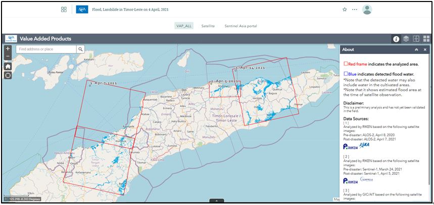
Sample of new Web-GIS page
Updated contents
1. Summarizing the information on the page
You can change the information being displayed simply by clicking the tabs at the top of the page. The previous version had many tabs showing the data provider organizations. In this updated version, only three tabs are displayed.
When you click the "VAP_ALL" tab on the left, all the Value-Added Products (VAPs) provided by the member organizations are displayed (this is the default status). Clicking the “Satellite” tab in the center, you will see all the satellite observation data provided. For the “Sentinel Asia portal” tab in the right, you will see the page linked to the Sentinel Asia’s Emergency Observation Request (EOR). (Please note that an “ALOS-2 RGB composite” tab may also be added in some cases.)
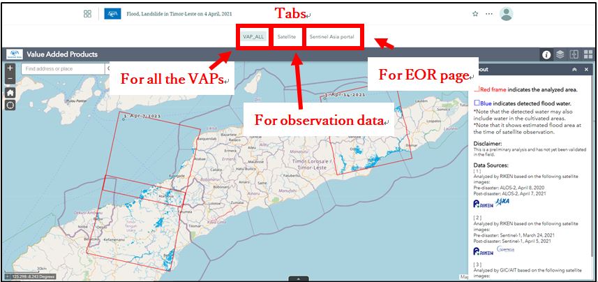
Similar information is now compiled in a single tab to summarize the information, enabling the user to easily compare multiple VAPs and observation data. This also ensures that pages are loaded more quickly when transferring the tabs, guaranteeing a stress-free experience.
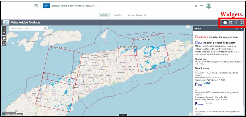
2. Simpler with fewer Widgets
Widgets are located in the upper-right section. The previous version displayed many widgets, some of which were not frequently used. This updated version has a simpler presentation, showing only four very useful widgets. The functions of the new widgets are as follows.
- About: Shows a summary of the information displayed.
- Layer List: Selects the information to be displayed.
- Swipe: Enables to hide the information displayed at the top and compare it with the information below it.
- Basemap Gallery: Changes the background map (default map is the Open Street Map).
3. Displaying the analysis area of VAPs
The previous version did not display the analysis area of the VAPs. However, the new version shows the analysis area of the VAPs inside a red frame, so when you see that there is no confirmation of damage within the area, this makes it easier to understand that the area is not damaged.
Questionnaire feedback from Sentinel Asia members
In January 2022, the Secretariat conducted a questionnaire on the updated version of Web-GIS to obtain feedback from Sentinel Asia members. We appreciate the cooperation of the 18 members who responded. All of the respondents stated that they prefer the updated version and are satisfied with it.
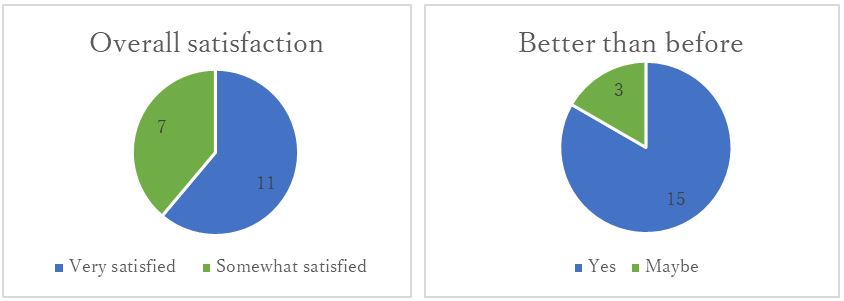
Results of the questionnaire (based on 18 replies)
Here is some of the feedback:
- Very helpful tool for requestor and other JPT members!!
- We are very thankful for the membership.
Conclusion
Sentinel Asia Web-GIS will continue to be improved for the benefit of the members. If you have any requests or suggestions for improvements, please do not hesitate to contact the Secretariat.