Mr. Ulan Abdybachaev, Central Asian Institute for Applied Geosciences (CAIAG)
Since its participation in 2009, the Central Asian Institute for Applied Geosciences (CAIAG) has been an active member of Sentinel Asia. It was founded by the Government of the Kyrgyz Republic and the German Research Center for Geosciences but it also works to respond the disasters in Central Asian countries, not limited to Kyrgyz. The Sentinel Asia Secretariat interviewed Mr. Ulan Abdybachaev, Depute of Head of Department of Geodynamics and Georisks, CAIAG, to introduce the latter’s activities relating to Sentinel Asia.
 |
| Mr. Ulan Abdybachaev, Central Asian Institute for Applied Geosciences (CAIAG) |
Sentinel Asia Secretariat
CAIAG joined as a Joint Project Team (JPT) member of Sentinel Asia in the very early days and has contributed as a Data Analysis Node (DAN). The Secretariat is very grateful for your contribution. First of all, could you introduce your organization to our readers?
Mr. Ulan Abdybachaev
The Central Asian Institute for Applied Geosciences (CAIAG) was established in 2002 by the Government of the Kyrgyz Republic and the German Research Center for Geosciences, Potsdam, Germany. At CAIAG, there are two co-directors, one representing the Kyrgyz Republic and the other representing the German side. As of today, the total number of employees amounts to 62, including administrative and technical staff. Our research spans geodynamics and geohazards; climate, water, and geo-ecology; and the usage and protection of natural resources. We emphasize technical infrastructure development, information management, and the education and professional qualification of our researchers. Although the focus on remote sensing at CAIAG has somewhat diminished in recent years, our Department of Geodynamics and Georisks remains a key player in conducting remote sensing analyses.
Sentinel Asia Secretariat
CAIAG is very active in disaster response in Central Asian countries. Could you explain the framework of your cooperation with these countries? Also, could you explain how you support these countries in the area for the Sentinel Asia Emergency Observation Requests (EORs)?
Mr. Ulan Abdybachaev
In the context of our scientific research collaboration, our contact information is grounded in memorandums of cooperation signed previously. We maintain our relationship through e-mail requests.
However, considering the culture, mentality, and economic and social aspects of Central Asian countries, and based on our experience with Emergency Observation Requests (EORs), I have identified a pressing issue. Specifically, there is a lack of consistent feedback from disaster management organizations in Central Asian countries. This problem often arises when the designated contact person leaves their position within the organization, and the new appointee is not informed or engaged with ongoing projects.
A potential solution is to update existing memorandums and conduct a ‘reset’ or updating our collaboration with the objectives of Sentinel Asia.
Sentinel Asia Secretariat
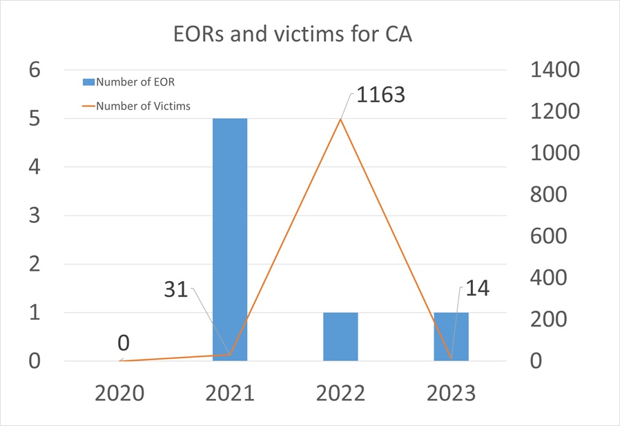
We have had 11 EORs from CAIAG so far. Could you pick out some cases and show how the data/products from Sentinel Asia were used in these countries?
Mr. Ulan Abdybachaev
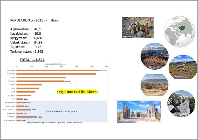
Most of the 11 cases were water-related, such as flooding in Kazakhstan in 2010, or the trigger was rainfall resulting in landslides in Tajikistan, and also landslides and mudflows in Kyrgyzstan and Uzbekistan in 2021. However, there were also earthquakes in Afghanistan in 2022 and a fire in Kazakhstan in 2023 .
Satellite images such as ALOS PALSAR as well as other optical images were often used.
Sentinel Asia Secretariat
About the past EORs from CAIAG, could you tell us about memorable cases and where the data from Sentinel Asia was used effectively, and why?
Mr. Ulan Abdybachaev
Regarding memorable cases, I recall the forest fire in Kazakhstan in 2023 and the mudflow event in Kyrgyzstan in 2021. For these events, satellite data from members of the Sentinel Asia organization were effectively used. These data were used by the Ministry of Emergency Situations to analyze and assess the zones and scale of damage of these events.
I think what has been successful has been the solidarity within the Sentinel Asia community, which is truly a key element in achieving resilience and effective response to catastrophic events. And taking this opportunity, I would like to express my deep gratitude to everyone who is involved in this program and who supports and contributes to its development.
 |
Sentinel Asia Secretariat
What are the merits of Sentinel Asia, for example, image processing by DAN in a timely manner.
Mr. Ulan Abdybachaev
I believe that timely image processing is a foundational aspect and one of the principal advantages of Sentinel Asia. This efficiency is crucial for an objective assessment of the magnitude of natural events, enabling the extraction of critical data to prioritize decisions effectively. Additionally, Sentinel Asia is invaluable for its capacity to provide diverse types of data, including optical and radar imagery. These resources offer a comprehensive view of the situation, enhancing our understanding of the unfolding events.
Sentinel Asia Secretariat
Are there any challenges relating to disaster management and other socioeconomic conditions in Central Asia that could be solved by Sentinel Asia or other satellite technologies? Or if you have already coordinated with satellite technologies on your activities, could you introduce examples of them?
Mr. Ulan Abdybachaev
As mentioned earlier, one of our main challenges is the limited number of expert human resources, which significantly impacts our activities. In addition to human resources, socioeconomic conditions also pose challenges to utilizing satellite information, particularly in Kyrgyzstan, Kazakhstan, and Uzbekistan. The field of remote sensing is not widely popular in these regions, and due to its low popularity coupled with limited budgets and incomes, young staff frequently transition to new fields. This challenge necessitates efforts to change perceptions and raise the profile of the remote sensing sector. Furthermore, the field of remote sensing is closely linked with national security, often leading to conversations being curtailed due to security concerns. Despite these challenges, CAIAG is actively working to change this situation. For instance, recent discussions in Kyrgyzstan about developing an early warning system for earthquakes have provided CAIAG with an opportunity to showcase the potential of the space industry and remote sensing in enhancing evaluations for early warning systems.
One of the challenges faced in Central Asia is flooding from glacial lake outburst floods. CAIAG is involved in implementing the project “Reducing the vulnerability of the population in the Central Asian region to glacial lake outburst floods (GLOF) in the context of climate change,” with financial support from the Adaptation Fund and UNESCO, aimed at addressing such challenges. The project covers Kazakhstan, Kyrgyzstan, Tajikistan, and Uzbekistan. One of the key outcomes of this project is the use of satellite imagery to assess the level of threat from glacial lake outburst floods, which will make a significant contribution to effectively addressing these challenges in the target countries.
Sentinel Asia Secretariat
Do you have any expectations for Sentinel Asia, and conversely, what CAIAG can contribute to Sentinel Asia?
Mr. Ulan Abdybachaev
Our expectations from the Sentinel Asia program boil down to the continuation of cooperation and ensuring sustainable development in the Central Asia region. We place particular emphasis on technical support and consultations, as we consider them crucial in the context of improving disaster response. As part of the development and popularization of remote sensing methods and data, CAIAG launched a master’s program in Applied Geology (Georisks) in 2021. The availability of data on 11 events in the Central Asia region, which were previously mentioned, has become the basis for creating case studies. These and other cases will be used to train young professionals and demonstrate opportunities for target users. With the support of Sentinel Asia, training CAIAG staff in new skills for post-processing satellite images and remote sensing products will also make a significant contribution to enhancing the potential for quality knowledge transfer and tools for the younger generation.