Dr. Saeed Hussain Al Mansoori, Mohammed Bin Rashid Space Centre (MBRSC), UAE
The Mohammed Bin Rashid Space Centre (MBRSC), founded in 2006, is home to the United Arab Emirates' National Space Program. MBRSC builds and operates earth observation satellites, offering imaging and data analysis services. MBRSC has been a member of Sentinel Asia since 2017. In addition to its contribution of supplying observation data as a Data Provider Node (DPN), MBRSC has also been supporting Emergency Observation Requests (EORs) as a Data Analysis Node (DAN) by providing many value-added products.
MBRSC co-hosted Sentinel Asia's Joint Project Team Meeting (JPTM) in February 2026 (JPTM 2025), in Dubai, UAE. On this occasion, the Sentinel Asia Secretariat interviewed Dr. Saeed Al Mansoori, Director, Remote Sensing Department, and discussed MBRSC's relationship with Sentinel Asia.
 |
| Dr. Saeed Al Mansoori, Director, Remote Sensing Department, MBRSC |
Sentinel Asia Secretariat:
MBRSC joined Sentinel Asia in 2017, and this is the first time JPTM has been held in the UAE, West Asia and the first time MBRSC has served as a co-organizer. Could you share the background and motivations behind MBRSC's decision to be a member of Sentinel Asia, and the purpose and outcome of hosting JPTM this year?
Dr. Saeed Hussain Al Mansoori:
MBRSC joined Sentinel Asia in 2017 as part of the UAE's commitment to strengthening regional and international cooperation in the use of space technologies for disaster management and environmental resilience. From the beginning, the motivation was clear: disasters do not recognize borders, and space-based Earth observation can play a vital role in supporting timely response, damage assessment, and recovery planning.
As a space centre with growing Earth observation capabilities, MBRSC saw membership in Sentinel Asia as an opportunity to both contribute to and benefit from a collaborative network of space agencies and disaster management organizations across Asia and the Pacific. Through this partnership, knowledge exchange, capacity building, and data sharing have been enhanced, enabling more effective use of satellite imagery and geospatial analytics in emergency situations.
Hosting the Joint Project Team Meeting (JPTM) this year in the UAE, the first time in West Asia and the first time for MBRSC to serve as a co-organizer, reflects the UAE's increasing role in the global space and disaster management community. The purpose of hosting JPTM was to bring the Sentinel Asia community together to review progress, share operational experiences, and strengthen coordination among member organizations.
The outcomes have been very positive. The meeting has helped deepen technical collaboration, expand engagement with new stakeholders from the region, and highlight how emerging technologies such as artificial intelligence can further enhance disaster response workflows. It has also reinforced the UAE's position as a regional hub for space applications that serve humanity, particularly in areas related to climate resilience and disaster risk reduction.
Overall, hosting JPTM has not only strengthened Sentinel Asia as a partnership but has also opened new doors for cooperation between West Asia and the broader Asia-Pacific community in using space for the benefit of society.
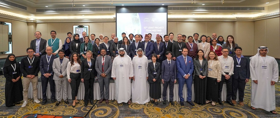 |
| Participants at JPTM 2025 |
Sentinel Asia Secretariat:
This three-day meeting comprised discussions, workshops, and hands-on training, among other activities. Having finished the meeting, what are your overall impressions of JPTM this year?
Dr. Al Mansoori:
Overall, JPTM this year left a very strong and positive impression, both in terms of technical depth and the level of international cooperation.
One of the most notable aspects was the balance between strategic discussions and practical capacity building. The program was not limited to presentations—it included multiple user sessions where countries shared real disaster response experiences, such as flood events, landslides, earthquakes, and extreme rainfall impacts. These case studies demonstrated how Sentinel Asia support is being translated into real operational value on the ground.
The hands-on training workshops were another major highlight. Over the three days, participants took part in practical technical sessions on topics such as activating Sentinel Asia support mechanisms, flood mapping using SAR data in QGIS, population exposure analysis using Google Earth Engine, and the use of rainfall and hydrological monitoring systems. These sessions ensured that participants not only learned concepts but also developed practical skills they can directly apply in their home institutions.
It was also very encouraging to see strong emphasis on emerging technologies. Several sessions focused on artificial intelligence, digital twins, and advanced data analytics for disaster risk management, including AI-based damage mapping and next-generation geospatial tools. This shows how Sentinel Asia is evolving from being only a data-sharing initiative into a more advanced, technology-driven support framework.
Another important impression was the diversity of participation. The meeting brought together space agencies, disaster management authorities, research institutions, and international organizations. This multi-stakeholder engagement is essential because effective disaster management depends not only on satellites, but also on strong coordination between data providers, analysts, and decision-makers.
From MBRSC's perspective as co-organizer and host, it was particularly rewarding to see West Asia more actively connected with the broader Asia-Pacific Sentinel Asia community. The strong engagement, knowledge exchange, and collaborative atmosphere clearly demonstrated that JPTM is not just a meeting, it is a working platform that strengthens regional resilience through space-based solutions.
In summary, JPTM this year was impactful, practical, and forward-looking. It reinforced the value of international cooperation, strengthened technical capacities among participants, and highlighted how advanced space technologies can better support disaster preparedness, response, and recovery.
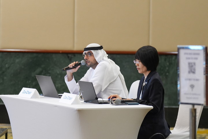 |
| Dr. Al Mansoori co-chaired JPTM 2025 along with Ms. Shiho Taguchi, Acting Executive Secretary of Sentinel Asia from JAXA |
Sentinel Asia Secretariat:
Did you have any topics or agenda items at JPTM that are especially important to MBRSC?
Dr. Al Mansoori:
Yes, several topics in this year's JPTM were particularly important to MBRSC, as they closely match our technical priorities and our role in supporting disaster management through Earth observation.
One key area of interest was the strong focus on flood monitoring and analysis. Multiple training workshops covered flood mapping using SAR data, urban flood assessment, rainfall monitoring, and hydrological modelling. These topics are highly relevant to MBRSC. The hands-on sessions using tools such as QGIS and Google Earth Engine were especially valuable because they align with the type of operational workflows we are developing and supporting.
Another important topic for MBRSC was the integration of artificial intelligence and advanced analytics into disaster risk management. Sessions addressing AI-based damage mapping, digital twins, and next-generation geospatial tools strongly resonated with our direction of embedding AI into Earth observation applications. These discussions help us connect our internal R&D efforts with broader regional practices and identify opportunities for collaboration and knowledge exchange.
The user sessions were also highly relevant. Presentations from disaster management agencies and operational users highlighted real-world challenges and expectations from Sentinel Asia. This user perspective is critical for MBRSC, as it helps ensure that the satellite products and analytical services we develop remain practical, user-oriented, and responsive to real emergency needs.
Finally, the agenda items related to coordination mechanisms—such as how to activate Sentinel Asia support and how to better link with international frameworks—were very important. These discussions strengthen institutional readiness and clarify procedures, which is essential for ensuring that space-based support can be delivered quickly and effectively during actual disaster events.
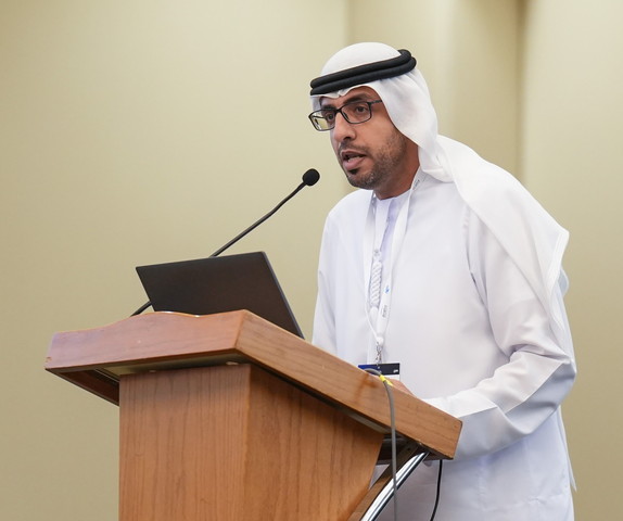 |
 |
Dr. Al Mansoori at JPTM 2025
Sentinel Asia Secretariat:
And how did you find the Special Session "From Pixels to Preparedness: Satellite Imagery and AI for Disaster Risk Management in the UAE" and hands-on training session "Flood Mapping Using SAR Satellite Data in QGIS"? What were the comments/responses from the participants?
Dr. Al Mansoori:
Both the Special Session and the hands-on SAR flood mapping training were among the most impactful parts of the meeting, and the feedback from participants was very encouraging.
The Special Session titled "From Pixels to Preparedness: Satellite Imagery and AI for Disaster Risk Management in the UAE" was particularly well received because it showcased practical, real-world applications rather than only theory. The panel brought together experts from government, academia, and industry in the UAE, which helped demonstrate how satellite data, AI, and geospatial analytics are already being integrated into national disaster risk management workflows. Many participants appreciated seeing a full ecosystem perspective—from data acquisition to analysis and decision support—and several mentioned that it provided useful ideas they could adopt within their own countries and institutions.
As for the hands-on training session on "Flood Mapping Using SAR Satellite Data in QGIS," it generated very positive responses, especially from technical participants. SAR data can sometimes feel complex, so having a step-by-step practical session in an accessible platform like QGIS made a big difference. Participants valued the fact that they were not just listening, but actually performing the workflow themselves. Several attendees commented that this kind of practical exercise increases their confidence to apply similar methods during real flood events back home.
Overall, both sessions reflected something very important: the need to connect advanced space technologies with operational readiness. The Special Session highlighted strategic and institutional approaches, while the SAR training strengthened individual technical capacity. Together, they helped move the discussion from "pixels" to real preparedness—which is exactly the direction we want Sentinel Asia activities to go in.
Sentinel Asia Secretariat:
From my point of view, it seems that the UAE faces relatively fewer natural disasters than other Sentinel Asia member countries. How does MBRSC view the significance of participating in Sentinel Asia? What value does this cooperation bring to the UAE and MBRSC?
Dr. Al Mansoori:
That's a very thoughtful observation, and it's true that the UAE experiences fewer large-scale natural disasters compared to some other Sentinel Asia member countries. However, from MBRSC's perspective, participation in Sentinel Asia is still highly significant, both nationally and internationally.
First, disaster risk is evolving. While the UAE may not face frequent earthquakes or typhoons, we are increasingly exposed to climate-related hazards such as extreme rainfall, flash floods, dust storms, coastal changes, and heat-related environmental stresses. Satellite-based Earth observation and geospatial analytics are essential tools for monitoring these risks, improving preparedness, and supporting national resilience strategies. Through Sentinel Asia, MBRSC gains access to shared expertise, best practices, and operational experiences from countries that deal with disasters more frequently, which strengthens our own readiness.
Second, Sentinel Asia is not only about responding to disasters at home—it is also about contributing internationally. The UAE has positioned itself as an active international cooperation and development partner, and space-based support is part of that role. By participating in Sentinel Asia, MBRSC can contribute satellite data, technical expertise, and analytical support to other countries during emergencies. This reinforces the UAE's commitment to using advanced technologies for the benefit of humanity and strengthens its role as a responsible spacefaring nation.
For MBRSC specifically, the value is also technical and institutional. Engagement in Sentinel Asia provides a real operational environment where new methods, tools, and workflows can be tested and improved. It connects our engineers and analysts with a network of space agencies, disaster management authorities, and research institutions, encouraging knowledge exchange and joint development of solutions. This continuous interaction helps us enhance our own systems, platforms, and response procedures.
Sentinel Asia Secretariat:
What do you expect from Sentinel Asia in the future and how will MBRSC contribute to Sentinel Asia as a Data Provider Node as well as a Data Analysis Node, in addition to co-organization of JPTM 2025?
Dr. Al Mansoori:
Looking ahead, MBRSC expects Sentinel Asia to continue evolving from a data-sharing platform into a more integrated, technology-enabled disaster support network.
One key expectation is deeper operational integration—faster tasking, more streamlined data access, and stronger coordination between data providers, analysis nodes, and end users. As disasters become more complex and climate-related hazards increase, timely and well-coordinated space-based support will be even more critical.
Another important direction is the wider adoption of advanced technologies such as artificial intelligence, automated change detection, and cloud-based processing platforms. These tools can significantly reduce the time between data acquisition and actionable information. Sentinel Asia has already begun moving in this direction, and we expect this to expand further, with more shared tools, common methodologies, and collaborative development among member organizations.
From MBRSC's side, we are committed to contributing in multiple roles.
As a Data Provider Node, MBRSC will continue to make satellite imagery and derived products available, particularly in support of rapid mapping and disaster assessment. We are also working to enhance the timeliness and usability of the data through improved processing pipelines and value-added layers.
As a Data Analysis Node, MBRSC will contribute more analytical products, especially those enhanced by AI and advanced geospatial techniques. This includes automated damage assessment, flood extent mapping, and other thematic analyses that can support decision-makers during emergency response.
Beyond technical contributions, MBRSC will also continue to play an active role in capacity building. The strong focus on hands-on training at JPTM 2025 reflects our belief that building local technical skills across the region is just as important as providing data. We plan to support future training activities, share methodologies, and collaborate on joint research and development initiatives within the Sentinel Asia framework.
In summary, we see Sentinel Asia's future as more connected, more technology-driven, and more operational—and MBRSC is fully committed to contributing data, analysis, and expertise to support that vision.
Sentinel Asia Secretariat:
Could you tell us about MBRSC's future plans for the development of Earth observation satellites and other EO-related programs?
Dr. Al Mansoori:
That's an exciting topic for us. At MBRSC, the future of Earth observation is being shaped around higher performance, smarter data use, and stronger integration with national needs.
On the satellite side, our direction is toward constellations rather than single missions. Future Earth observation systems will focus on higher revisit frequency, improved spatial and spectral capabilities, and more flexible tasking to support time-critical applications such as disaster response, environmental monitoring, and infrastructure assessment. The goal is not only to capture better images, but to ensure that observations are timely, consistent, and suited for operational services rather than one-off studies.
At the same time, we are placing strong emphasis on value-added data rather than raw imagery alone. Future EO programs at MBRSC are closely linked to the development of AI-driven analytics, automated feature extraction, and decision-support products. This means that alongside satellite development, equal effort is being invested in cloud processing platforms, big data architectures, and advanced algorithms that can turn satellite data into actionable insights for government entities and other stakeholders.
Another important direction is the integration of EO with national digital transformation initiatives. Earth observation data will increasingly feed into digital twin platforms, environmental monitoring systems, climate resilience planning, and smart city applications. This requires tighter links between space systems, geospatial infrastructure, and end-user platforms on the ground.
MBRSC is also committed to strengthening international cooperation in future EO programs. We see collaboration—whether through data sharing, joint research, or coordinated applications—as essential for addressing global challenges such as climate change, disaster risk reduction, and sustainable development.
Finally, capacity building remains central. As we develop more advanced satellites and analytics systems, we are equally focused on developing national talent in satellite engineering, geospatial science, and AI. The long-term vision is not only to operate advanced EO missions, but to ensure that the UAE continues to grow as a regional hub for space-based Earth observation and its applications.
In summary, MBRSC's future EO plans combine more capable satellites, smarter analytics, stronger integration with national systems, and deeper international cooperation—all aimed at turning space data into a real impact on Earth.