-
Japan provides support to the Philippines in response to the earthquake in Cebu
-
Japan's Support for Response to the Oil Spill Incident in the Philippines
-
Satellites Watch Over Us From Above
-
PhilSA shows journalists extent of Mindoro oil spill as captured by satellite images
-
PhilSA joins Asia-Pacific initiative to provide satellite data for DRRM activities
-
NTU scientists create proxy maps of damage from Turkey-Syria quake to guide rescue work
-
Earthquake in Turkey and Syria: How Satellites Can Help Rescue Efforts
-
Images from Taiwan satellite aid in Turkey earthquake relief
Earthquake in Indonesia in September 2018
Posted on Embassy of Japan in the Philippines on Oct 7, 2025
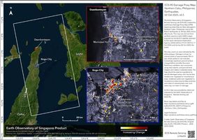
On 02 October 2025, the Japan Aerospace Exploration Agency (JAXA) provided emergency observation and satellite images of the situation in Northern Cebu taken by JAXA’s ALOS-2 (Advanced Land Observing Satellite-2) through the international cooperation framework of the Sentinel Asia.
On 02 October 2025, the Japan Aerospace Exploration Agency (JAXA) provided emergency observation and satellite images of the situation in Northern Cebu taken by JAXA’s ALOS-2 (Advanced Land Observing Satellite-2) through the international cooperation framework of the Sentinel Asia.
Posted on Embassy of Japan in the Philippines on Aug 8, 2024
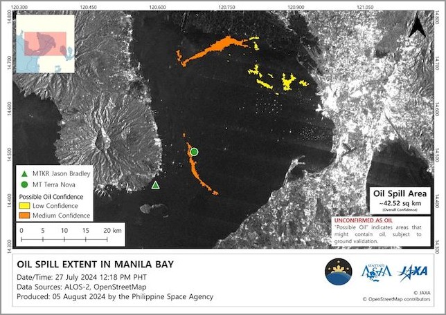
On August 7, the Japan Coast Guard (JCG) held an online meeting with the Philippine Coast Guard (PCG) to assist in response to the oil spill incident off the vicinity of the Manila Bay.
On August 7, the Japan Coast Guard (JCG) held an online meeting with the Philippine Coast Guard (PCG) to assist in response to the oil spill incident off the vicinity of the Manila Bay.

Posted on Renewable matter on 16 January 2024
Satellite data are revolutionizing the way we deal with natural disasters, from warning systems to mapping hazard areas to prevention.
Satellite data are revolutionizing the way we deal with natural disasters, from warning systems to mapping hazard areas to prevention.
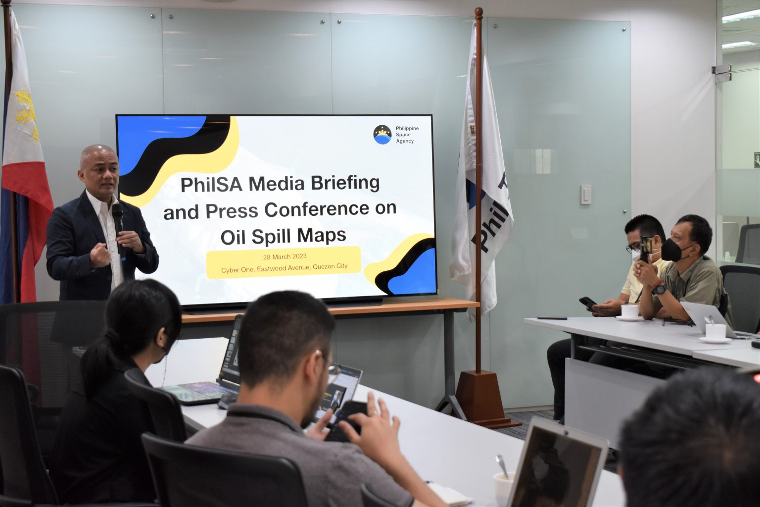
Posted on PhilSA news on 29 March 2023
Following the oil spill caused by the sinking of the MT Princess Empress vessel on 28 February 2023 off the coast of Oriental Mindoro, the Philippine Space Agency (PhilSA) produced maps showing the possible oil spill extent derived from satellite images.
Following the oil spill caused by the sinking of the MT Princess Empress vessel on 28 February 2023 off the coast of Oriental Mindoro, the Philippine Space Agency (PhilSA) produced maps showing the possible oil spill extent derived from satellite images.

Posted on PhilSA news on 2 March 2023
On 24 January 2023, the Philippine Space Agency (PhilSA) was accepted as a Data Provider Node (DPN) member of Sentinel Asia.
Sentinel Asia is an international initiative by the Asia-Pacific Regional Space Agency Forum (APRSAF) that supports disaster risk reduction and management (DRRM) activities in the Asia-Pacific region using space technology and Web-GIS. It works to enhance disaster preparedness and post-disaster recovery through the sharing of Earth observation technologies with near-real-time internet dissemination methods to improve safety and minimize the number of victims and social/economic losses resulting from disasters.
Posted on THE STRAITSTIMES, Singapore on 20 February 2023
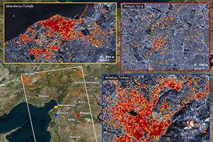
SINGAPORE - A few hours after a deadly earthquake devastated Turkey and Syria earlier in February, a team from Nanyang Technological University’s Earth Observatory of Singapore (EOS) began to build maps showing the extent of the damage in the afflicted regions.
SINGAPORE - A few hours after a deadly earthquake devastated Turkey and Syria earlier in February, a team from Nanyang Technological University’s Earth Observatory of Singapore (EOS) began to build maps showing the extent of the damage in the afflicted regions.
Posted on BRINK News on 14 February 2023
In disasters like the 7.8 magnitude earthquake and 7.5-magnitude aftershock that struck Syria and Turkey on February 6, 2023, international cooperation on satellite imaging plays a crucial role in the rescue and recovery efforts.
In disasters like the 7.8 magnitude earthquake and 7.5-magnitude aftershock that struck Syria and Turkey on February 6, 2023, international cooperation on satellite imaging plays a crucial role in the rescue and recovery efforts.
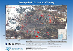
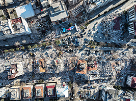
Posted on Focus Taiwan on 12 February 2023
Taipei Feb. 12 (CNA) Taiwan's Formosa Satellite 5 (Formosat-5) has been providing satellite imagery to assist disaster relief work in Turkey following a deadly magnitude 7.8 earthquake in that country last Monday, with its latest orbital rotation scheduled for Feb. 13.
Taipei Feb. 12 (CNA) Taiwan's Formosa Satellite 5 (Formosat-5) has been providing satellite imagery to assist disaster relief work in Turkey following a deadly magnitude 7.8 earthquake in that country last Monday, with its latest orbital rotation scheduled for Feb. 13.
Broadcasted by Euronews on 22 February 2019
Dr.Shiro Kawakita of JAXA has been interviewed on disaster management by JAXA's satellite from the euronews, and Dr. Kawakita explained Sentinel Asia's efforts on earthquake in Indonesia in September 2018.
On 22 February 2019, it was broadcast on the euronews and released on its website.
https://www.euronews.com/
Dr.Shiro Kawakita of JAXA has been interviewed on disaster management by JAXA's satellite from the euronews, and Dr. Kawakita explained Sentinel Asia's efforts on earthquake in Indonesia in September 2018.
On 22 February 2019, it was broadcast on the euronews and released on its website.