Kazuya Kaku received a master’s degree in applied mathematics and physics from Kyoto University, Japan, in 1978 and a PhD degree from Graduate School of Information Science and Technology, Hokkaido University, Japan, in 2010. He previously worked with the Satellite Applications and Operations Center of the Japan Aerospace Exploration Agency (JAXA) and the Sentinel Asia project to support disaster management in the Asia-Pacific region by applying satellite remote sensing and Web-GIS technologies.
His role in the Sentinel Asia (SA)
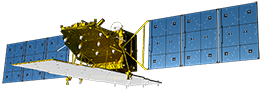
JAXA has begun engaging in support activities for disaster management using ALOS satellite launched in January 2006. He has been involved in this activity of JAXA from that time and worked to establish the SA framework and determine the implementation plan as SA secretariat. See: https://aprsaf.org/interviews/interviews_2017/interviews02.php
Introduction
When I joined SA in January 2006, my task was to study and make the concept of SA Step 1 implementation by the 2nd Joint Project Team Meeting in June 2006 in Bangkok, and to start its operation in October 2006 when ALOS’s routine operation started.
† History of Start-up
This is before my participation in SA, and there were efforts of stakeholders in the framework of APRSAF from 2004 to 2005 leading up to the launch of SA. I think that Dr. A. Held, Dr. L. Samarakoon and Mr. Kwoh Leong Keong et al. know the background.
† Activity of Step 1
The SA Step 1 [1, 2] was carried out from 2006 through 2007, as a collaborative project of space agencies (APRSAF community) and disaster management organizations (Asian Disaster Reduction Center (ADRC) and member organizations), using primarily the Digital Asia (Web-GIS) platform provided by Keio University. It has demonstrated effective sharing and employing of disaster information obtained from Earth observation satellites and found issues to be solved.
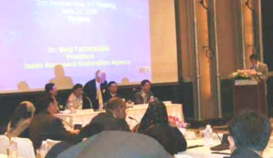
The second JPTM of Step 1 in June 2006 in Bangkok, hosted by GISTDS. Step-1 implementation plan was agreed.
† Activity of Step 2
Step 2 was rolled out to take the lessons of Step 1 from 2008 [3-5], as follows: (1) new Earth observation satellites have joined the DPN, (2) a new Step 2 information-sharing platform has been developed by JAXA, which includes information/data transmission to facilitate access to disaster-related information using WINDS satellite communications to overcome low internet bandwidth in several countries, (3) a new framework for satellite data analysis and value-adding, the Data Analysis Node (DAN) , has been organized, (4) the SA Success Story to collaborate with end users has started.
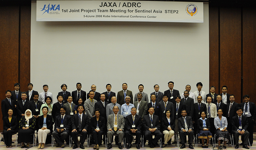
The first JPTM of Step 2 in June 2008 in Kobe, Japan, hosted by ADRC. Step-2 implementation plan was agreed. (Click to enlarge image)
Sentinel Asia Success Story is an activity started from Step 2 aimed at (1) outreach and cooperation for disaster risk reduction (DRR) in the mitigation / preparedness phase, (2) establishment of specific case-studies via regional cooperation that include end-users, (3) local awareness and knowledge transfer through capacity building, and (4) human resources and human network development. Among the first such case studies, JAXA has been implementing the SA success story in the Philippines since 2009. This figure shows landslide early warning prototype system in the framework of the SA Success Story in the Philippines.
Source: Presentation by A. S. Daag of PHIVOLCS at APRSAF-23 annual meeting.
† Transition to the Step 3
Considering the results of Step 2 operation and the feedback from the Joint Project Team (JPT) members, the concept of Step 3 was defined [6]. It extends the data services of SA further to provision of data for pre/post-disaster phases. At APRSAF-19, held in Kuala Lumpur in December 2012, several new recommendations for SA were adopted, including the successful completion of SA Step 2, in recognition of achieving the goals, and a declaration of the launch of the final phase of SA in 2013. The goal of Step 3 is to further expand SA’s activities to a wider regional reach, to better cover the entire disaster management cycle (the mitigation/preparedness phase, response phase, and recovery phase), to achieve faster delivery of disaster information products to end-users, and to utilize many and varied satellites, such as Earth observation, communication, and navigation satellites, with further operational collaboration and human networking by the JPT.
† The Most impressive experience
The Great East Japan Earthquake, a magnitude 9.0 earthquake, the strongest ever recorded in Japan, occurred on March 11, 2011. By March 14, 2011, cloud-free images of nearly all coastal areas have been obtained by ALOS and other satellites. As the first post-disaster data, these images were the most frequently used for geospatial results during the early response stages. International collaboration was shown to be very useful and important for dealing with disaster response. In particular, through the International Charter, very high-resolution data of commercial satellites were used to assess the conditions of collapsed buildings, determine the scope of damage to roads and railways, and carefully monitor the situation at the nuclear power plant.
Although it was difficult situation, it was shown that a space-based information effectively contributes to response during far-reaching catastrophes, and many valuable lessons were learned [7].
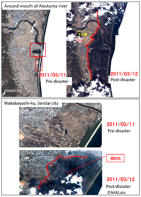
FORMOSAT-2 image (observed on March 12) analysis by NARLabs. This was the first impressive satellite-based information for me.
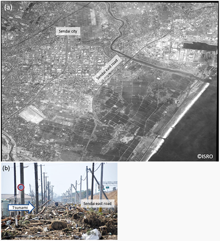
Cartosat-2 image observed on March 14, 2011, over Sendai area. Sendai east road worked as a dike, as shown in photo (b). Optical image (a) is provided by ISRO in the framework of Sentinel Asia. (Photo(b) is provided courtesy of ADRC.)
† Expectation to the future of Sentinel Asia
For further enhancement of SA, we proposed efforts called “SA evolution” at APRSAF-21, held in Tokyo in December 2014, with the necessity of evolving SA to activate and reinforce its expected functions. A steering committee was established, and a short-term plan and a long-term plan have been prepared. The short-term plan consists of three concepts: (1) “strategic management” by the steering committee, (2) “joint drive” to encourage participating organizations to be actively involved, and (3) “end-user-oriented approach” to respond to the needs of disaster areas and communities directly and quickly by accumulating information both before and after disasters, such as hazard maps, as well as education, through communities can enhance their capability to respond when disasters happen.
Conclusion
At the beginning, I did not know what I should do to apply satellite remote sensing to disaster management. More than 10 years have passed since then. It is thanks to the collaboration and efforts of all concerned that the SA continues and can be handed over to the next generation.
Conceptual illustration of applying satellite remote sensing to disaster management support
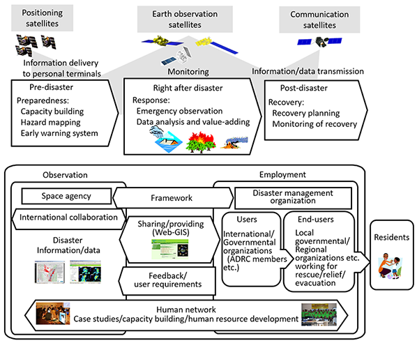
Through Sentinel Asia and JAXA’s activities within Japan, particularly the 2011 Great East Japan Earthquake, space-based response has been empirically proven to effectively support relief efforts during mass catastrophes, and requirements for applying satellite remote sensing to disaster management can be derived as follows [9, 10]: (1) Framework
An opinion survey shows that numerous general users request the establishment of a framework to supply satellite images free of charge and quickly in an emergency. A framework including data providers (space agencies), data analysts (universities, research institutes, etc.) and users (disaster management organizations) is necessary. (2) Activities
Users request to cover the entire disaster management cycle (preparedness, response, and recovery). Case studies and human networking through collaboration with users (including end-users), considering a regional background such as disaster type, disaster management systems, and organizational structure of disaster management in different countries are inevitable activities. (3) Users
SA is characterized by collaboration with users who are working for disaster management and response. Users are neither existing nor given ones; they must be developed and maintained as a part of project activities. (4) Data providers (space agency and data analysis organization)
Space agencies have requested continual efforts to realize user requirements, such as the timing of observation and providing data, the contents of satellite data and how users employed it, the quantity of satellite data, and others. (5) Sharing/providing system for disaster information/data
A sharing/providing system for data/information is essential for conducting disaster management support. It should function to share disaster information and data on Web-GIS and to transmit data to authorized persons. It also has a secure-access control function to limit users from viewing and downloading data according to the data policies of the data providers. (6) International collaboration
International collaboration is essential for disaster management support, particularly in the case of catastrophic disasters such as the 2011 Great East Japan Earthquake. As many satellites as possible are expected to support disaster management, particularly response, to maximize results based on: (i) the frequency of observation; (ii) rapid response, that is, to provide satellite-based disaster information to users (disaster responders) as quickly as possible; (iii) wide area coverage; (iv) types of satellite data with respect to high-resolution or wide-ranging surveillance, as well as SAR (X- or C- or L-band) or optical sensors; and (v) the uncertainty of getting excellent imagery depending on weather conditions. (7) Feedback from users
Feedback from users for each disaster event is valuable to data providers, whether it goes well or not. If not successful, user feedback contains lessons learned for improvement of activities; if successful, it is a measure and evidence of the results for data providers.
Message to the JPTM
JPT of SA, including disaster management organizations, is a unique community which characterizes SA. With this in mind, JPT members should take the opportunity of JPTM to promote the project.
Publications
[1] K. Kaku, A. Held, H. Fukui, M. Arakida, Sentinel Asia initiative for disaster management support in the Asia-Pacific region, Proc. SPIE 6412, 641203-641203–10 (2006). https://doi.org/10.1117/12.697822
[2] H. Kozawa, K. Kaku, Sentinel Asia: supporting disaster management in the Asia-Pacific region, The Full Picture (2007), Tudor Rose, Leicester (UK), pp. 174-176.
[4] K. Kaku, A. Ono, M. Kawai, Sentinel Asia Step2 – the Overview and Evolution from Step1, Proc. ISPRS Tech. Comm. VIII Symp. XXXVIII, Part 8 (2010) 56–61.
[5] K. Kaku, Sentinel Asia – space and ICT technologies towards disaster risk reduction across the Asia-Pacific region, Risk Returns (2011), Tudor Rose, Leicester (UK), pp. 123–126.
PreventionWeb of UNDRR: https://www.preventionweb.net/publications/view/20253
[6] K. Kaku, A. Held, Sentinel Asia: A space-based disaster management support system in the Asia-Pacific region, Int. J. Disaster Risk Reduct. 6 (2013) 1–17.
PreventionWeb of UNDRR: https://www.preventionweb.net/publications/view/69807
[7] K. Kaku, N. Aso, F. Takiguchi, Space-based response to the 2011 Great East Japan Earthquake: Lessons learnt from JAXA’s support using earth observation satellites, Int. J. Disaster Risk Reduct. 12 (2015) 134–153.
PreventionWeb of UNDRR: https://www.preventionweb.net/publications/view/69806
[8] S. Voigt, F. Giulio-Tonolo, J. Lyons, J. Kučera, B. Jones, et al., Global trends in satellite-based emergency mapping, Science. 353 (2016) 247–252. https://doi.org/10.1126/science.aad8728
[9] K. Kaku, Satellite remote sensing for disaster management support: A holistic and staged approach based on case studies in Sentinel Asia, Int. J. Disaster Risk Reduct. 33 (2019) 417–432.
PreventionWeb of UNDRR: https://www.preventionweb.net/publications/view/62930
Supplementary material: View document
Dr. Kazuya Kaku of JAXA was one of the honorable awardees to commemorate the 10th anniversary of SA because of his remarkably contribution to the setup and building of Sentinel Asia. Dr. Kaku has been working for the Sentinel Asia since its establishment. Dr. Kaku and his team prepared an implementation plan to realize the development of systems, activation of emergency observation and disaster prevention projects using GIS with step-by-step approach. Sentinel Asia has grown remarkably as one of the largest communities for disaster prevention in Asia. SA increased the member over 100 and responded to disasters over 300 times. In March 2019, Dr. Kaku retires from JAXA. He published his experiences in Sentinel Asia and JAXA as a book [10].
He welcomes comments/suggestions/reviews on his work and books.
Contact: kazuya.kaku(at)gmail.com


 [2] H. Kozawa, K. Kaku, Sentinel Asia: supporting disaster management in the Asia-Pacific region, The Full Picture (2007), Tudor Rose, Leicester (UK), pp. 174-176.
 [3] K. Kaku, Sentinel Asia – the next step, Risk Wise (2008), Tudor Rose, Leicester (UK), pp. 183-186.
 [4] K. Kaku, A. Ono, M. Kawai, Sentinel Asia Step2 – the Overview and Evolution from Step1, Proc. ISPRS Tech. Comm. VIII Symp. XXXVIII, Part 8 (2010) 56–61.
 [5] K. Kaku, Sentinel Asia – space and ICT technologies towards disaster risk reduction across the Asia-Pacific region, Risk Returns (2011), Tudor Rose, Leicester (UK), pp. 123–126.
 [6] K. Kaku, A. Held, Sentinel Asia: A space-based disaster management support system in the Asia-Pacific region, Int. J. Disaster Risk Reduct. 6 (2013) 1–17.
  [7] K. Kaku, N. Aso, F. Takiguchi, Space-based response to the 2011 Great East Japan Earthquake: Lessons learnt from JAXA’s support using earth observation satellites, Int. J. Disaster Risk Reduct. 12 (2015) 134–153.
  [9] K. Kaku, Satellite remote sensing for disaster management support: A holistic and staged approach based on case studies in Sentinel Asia, Int. J. Disaster Risk Reduct. 33 (2019) 417–432.
  [10] K. Kaku, An Introduction to Applying Satellite Remote Sensing to Disaster Management, Cambridge Scholars Publishing (2019), UK, 315 pp.
 Explanation of figure(Click to expand)